![[Ocean Oasis Conservation]](images/bnr-conservation.gif)
| |
|
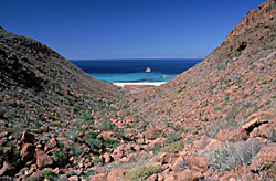
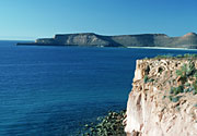
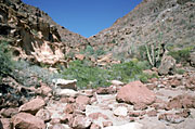
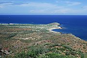
Espíritu Santo is a large (102 square km) island surrounded by a set of smaller islets known as Isla Partida, Los Islotes, La Ballena, El Gallo y La Gallina. It lies some 20 km east of La Paz. Because of its proximity to La Paz Bay, the island has been intensely used in the past and is still the most heavily visited island in the Sea of Cortés. It is littered with evidence of pre-Hispanic occupancy by the Pericú people. In the 19th century Don Gastón Vivés established the first pearl oyster farm in the world here. In the 1960s the state of Baja California Sur was granted legal status as a duty-free port, and the economy made a rapid transition from ranching and agriculture into commerce. As a result, communications developed rapidly: ferry ports, airports and the transpeninsular highway were built, and tourism started to take off. Some pioneering entrepeneurs who loved the natural beauty of the region started to develop a new brand of nature tourism that involved low-impact activities such as whale watching, kayaking, camping, and visits to the islands. Ecotourism was a new and revolutionary concept in Mexico, and has set an example for other regions. Coastal fishing in open panga boats also developed in the 1960s/1970s, and the fishermen started to use the island for temporary camps, 22 of which were in operation in 1999. Finally, a third social sector, academics and researchers, also developed with the new economy. A university and two research centers were established in La Paz in the 1970s, and researchers started to visit the island and to use it as a convenient field station. In spite of these uses, the island is in an extremely good state of conservation, an empirical fact that shows that low-impact nature tourism is indeed meeting its declared goals. In spite of the common use by many clients, the island, however, has legal owners. In 1976, two years before the decree protecting the islands of the Sea of Cortés was issued, the Secretaría de la Reforma Agraria (SRA, or Secretariat of Agrarian Reform) gave legal tenure of the island to the ejido (rural community) Alfredo Bonfil from La Paz. In the 1990s, facing a crisis of underground water depletion in the mainland, the ejido started to look for alternative, non-agricultural uses for their land and turned to Espíritu Santo. In 1992 the Mexican Constitution was amended, allowing communal ejido lands to be privatized, and the Bonfil ejido obtained authorization from SRA to parcel out 90 hectares in the island for development. Thus, an obvious conflict arose between the decree declaring all the islands in the Sea of Cortés a natural protected area, and the development authorization for Espíritu Santo. This lead in turn to a sort of legal stalemate, in which the ejido people have the right to develop the island, but have not been able to get the permits from the Secretariat of the Environment (SEMARNAP). In order to solve this situation, the ejido decided to cooperate in the preparation of a management plan for the island. They rapidly realized that the biggest chance of obtaining some income from the island was in being able to use it in a manner compatible with its status as a natural protected area. The management plan was done by CICIMAR, a local research center, with the participation of the Authorities of the Reserve, ISLA (a conservation NGO), The Nature Conservancy, the University of Baja California Sur (UABCS), the Mexican Center of Environmental Law (CEMDA), and, most importantly, the Bonfil ejido. A number of workshops were held, and in 1998 the final document was ready. The management plan of Espíritu Santo was the first of these plans to be finished, and became a landmark for regional conservation. The fact that the ejido landowners elected to participate, and in doing so recognized that there were restrictions to development in their own insular lands, was indeed a turning point for the growing development pressures that the islands continue to face. |
|
Text adapted from the conservation chapter of the book Island Biogeography in the Sea of Cortés, a forthcoming volume edited by Ted Case, Martin Cody, and Exequiel Ezcurra. The chapter was authored by Luis Bourillon, Antonio Cantú, Exequiel Ezcurra, María Elena Martínez, and Alejandro Robles. |
Photographs by Bradford Hollingsworth
Conservation | Site Index | Ocean Oasis
San Diego Natural History Museum & PRONATURA
© 2000 CinemaCorp of the Californias
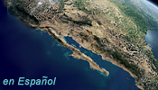
![[The Lower Gulf]](images/lowergulf.gif)