![[Ocean Oasis - Teacher's Guide]](images/bnr-oo-tg.gif) |
 |
|
|
|
|
![[Where in the World?]](images/whereintheworld.gif)
How do you locate a specific place on Earth? |
|
In the Film |
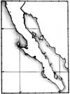
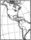
A satellite view of the west coast of North America zooms in on the Baja California peninsula, the Gulf of California, and the mainland of Mexico. This area is the destination for a number of migratory species. Several of these species, such as the Elegant Tern, Heermann's Gull, elephant seal, and gray whale, are featured in the film. |
|
Concept |
Any place on Earth can be identified using a coordinate grid system of latitude and longitude. Some animals migrate great distances between specific places. |
|
Objectives |
To locate places in Baja California and elsewhere using latitude and longitude; to explore animal migration |
|
Content |
Science, history/social studies, mathematics, language arts |
|
Background |
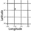
Mapmakers think of the world as a globe divided by vertical and horizontal lines. The lines running north and south are lines of longitude, or meridians. These lines of longitude come together at the North and South Poles and the distance between them is greatest at the equator. The Prime Meridian, 0 degrees, passes through Greenwich, England. Measurements are then made 180 degrees to the west and 180 degrees to the east from Greenwich. East-west lines of latitude circle the Earth parallel to the equator, which is 0 degrees. The poles are 90 degrees north and 90 degrees south latitude. Like an hour of time, a degree of latitude or longitude is divided into 60 minutes, and a minute is divided into 60 seconds. Any point on Earth can be identified using this coordinate system of longitude and latitude. For example, Washington, D.C., has the coordinates 38° 53´, 77° west. For various reasons humans have been moving from place to place for thousands of years. They have found their way using the sun and stars, sextants, maps, charts, compasses, and recently the Global Positioning System, or GPS. Many animals migrate, or move from one place to another place on a seasonal basis, seeking food or places to breed. Unlike humans, they do not use charts or instruments. How do they find their way? In Ocean Oasis, several migratory animals are featured. Gray whales, for example, migrate from summer feeding grounds around the Bering Sea near Alaska to lagoons along the west coast of Baja California—a journey that, in each direction, takes nearly four months and spans approximately 5500 miles (9000 km). The fact that animals migrate is well documented. However, much work needs to be done to understand how they find their way to the same area year after year and generation after generation. |
|
On the Web |
See the Ocean Oasis Field Guide for more about the Elegant Tern, Heermann's Gull, elephant seal, and gray whale. |
![[Materials]](images/materials.gif)
Part B
Migration |
![[Procedure]](images/procedure.gif)
Part A
Location (individuals, small groups)
|
|
Part B
Migration (individuals, small groups)
|
|
Local Connection
Key Words |
|
Continue to Activity 2: What's an Oasis? |
Teacher's Guide Contents
Field Guide | Site Index |
Ocean Oasis: The Film
|
|
© 2000 San Diego Natural History Museum |