![[Ocean Oasis Field Guide]](images/bnr-oo-field.gif)
| |

|
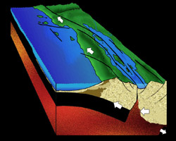
Late Miocene Epoch, 13 to 5 million years ago |
|
|
As the Pacific Plate continues its piracy of the western edge of the North American Plate, the floor of the rift valley drops below the level of the sea to create the Proto Gulf of California. Prior to 5 million years ago the Colorado River did not flow into the Gulf of California, but flowed somewhere to the east and south. Tropical sea life flourished in the Gulf as evidenced from the extensive fossil bed from this time period. The Gulf of California extended northward all the way to just north of the Coachella Valley in Southern California. The San Andreas Fault and other strike slip faults started during this time period, and so the newly created peninsula began to move northward. |
|
|
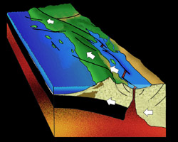
Pliocene Epoch 5 to 2 million years ago |
|
|
The crust beneath the Gulf of California becomes extended beyond its capacity and tears apart, so that magma welling up to fill the cracks begins to form new oceanic crust. At about 5 million years ago, the Colorado River changes course and begins to flow into the Northern Gulf of California, filling it in with thick deposits of sediment. Occasionally, huge landslides called sturzstroms would wreak havoc. Possibly triggered by earthquakes, whole sides of mountains occasionally would break loose and within a time frame of less than 10 seconds, travel 10 to 15 miles to slam into the tranquil waters of the Gulf. One such event is preserved in eastern San Diego County in the Anza-Borrego Desert State Park. |
|
|
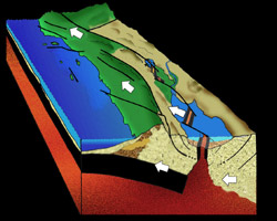
Pleistocene Epoch to today, 2 million years to 0 million years |
|
|
Great uplifting of Southern California and Baja California result in very high mountains to over 10,000 feet (3050 m). The northern portion of the Gulf of California is filled in with 20,000 feet (6 km) of sediment brought in by the Colorado River and surrounding land. Deep underneath the sediments, new oceanic crust continues to form from upwelling magma. Some of this magma melts into the thick sediments that fill the Northern Gulf, coming close enough to the present day surface to cause hot springs and other geothermal phenomena. Power companies in California and Baja California are tapping these hot spots to produce electrical power. |
|
Text by Brad Riney
Diagrams by Lee Ellingson of Masters Presentation
Graphics (based on drawings by Brad Riney)
Plate Tectonics
Field Guide |
Site Index |
Ocean Oasis Introduction
|
|
© 2000 San Diego Natural History Museum |