![[Ocean Oasis Field Guide]](images/bnr-oo-field.gif)
| |
|
|
|
|
Geography and Climate
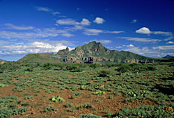
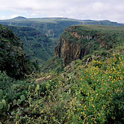
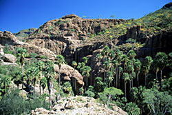
The Sierra de San Francisco lies south of the state line separating Baja California and Baja California Sur, located northeast of the highway, between Guerrero Negro and San Ignacio. It is the northernmost of a series of volcanic ranges running the length of the eastern side of Baja California Sur. It is an irregular volcanic range approximately 1600 m (4800 ft) high, drained by many steep canyons, which provide a setting for palm groves and mesquite forests. The rugged terrain makes access to the interior quite difficult, both for the inhabitants and for visiting researchers. Many areas are accessible only by foot and by pack animals.
This mountain range, along with its dramatic eastern neighbor, the Volcan las Tres Vírgenes, and the Sierra Guadalupe form the eastern edge of the Vizcaíno Desert, and provide a link between the tropical components of the southern peninsula and temperate influences of the north. The small amount of scientific documentation that has been performed indicates that a sort of biological mosaic of species from both tropical and temperate climates exists in this area.
Vegetation and Wildlife
The topography and habitats of these mountain ranges are quite varied and provide refugia for species from both north and south. In the past, when sea levels were higher and the surrounding low deserts were under water, these mountain ranges probably provided the only corridor for plant and animal dispersal along the peninsula.
Adding to the appeal of the region, not only can many species' range extensions be found here, but many endemic species are present, and it is presumed that various new species may yet be discovered in this region. During the 1997 Lindblad Binational expedition to this area, San Diego Natural History Museum botanist Jon Rebman took some specimens of a large number of Brahea sp. palms for the Museum. These palms are discussed in the Sierra de San Francisco palm article (coming soon to this website).
The occurrence of some plant species in the area is still a mystery.
An example is the Mexican Blue Oak (Quercus oblongifolia), which occurs in the central peninsular mountains, but is disjunct from its main populations in northern Sonora and southeastern Arizona. There are many other unexpected plant distributions from the expedition sites that are helping scientists to understand biogeographical trends.
Human History
Although the Sierra de San Francisco has had little study by biologists, it has long attracted visitors—both academic researchers and awed tourists—wanting to see the dramatic rock art left by indigenous inhabitants of the past.
|
Plants of Interest
(pages coming soon)
|
Text by Judy Gibson, based on articles by Jon Rebman and Bob Lauri
Photographs by Bradford Hollingsworth
Field Guide |
Site Index |
Ocean Oasis Introduction
|
|
© 2000 San Diego Natural History Museum |