![[Ocean Oasis Field Guide]](images/bnr-oo-field.gif)
| |
|
|
|
|
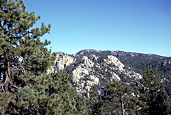
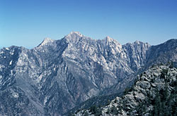
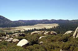
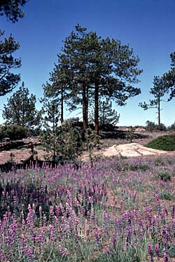
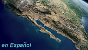
Those who picture Baja California as an unrelieved desert would be surprised to discover the highest part of the backbone of the peninsula covered by conifer forests, with winter snows and summer-flowered meadows. This is the Sierra de San Pedro Mártir, an island of rugged forested ridges and broad meadows, standing high above the coastal slopes to the west and dropping sharply to the San Felipe desert on the east. An adventurer who arrives at the top will find ranches and beautiful isolated camp sites surrounded by giant old growth Jeffrey and lodgepole pines, and extensive groves of quaking aspens. Hiking trails lead to Blue Bottle, a 2900 m (9500 ft) rise, or to Picacho del Diablo at 3100 m (10,153 ft), the highest point on the peninsula of Baja California. Geography and Climate The Sierra de San Pedro Mártir is a northwest-to-southeast oriented fault block feature consisting of massive granitic units that have been thrust during the past several million years to their present lofty position. Its geological history is closely related to the events that were responsible for the formation of the other peninsular range complex to the north, including the Sierra Juárez of Baja California, the Cuyamaca and Laguna mountains of San Diego County, and the San Jacinto mountains of Riverside County. Tectonic plate movements caused the solidified batholith to break along pressure lines (faults) into gigantic blocks that were subsequently forced upward. The mountain range's general configuration consists of a irregular but overall nearly flat surface, with elevations averaging 2400 m (8000 ft) in the north and slowly decreasing throughout its nearly 100 km (60 miles) length to the south. From the eastern escarpment across to the western edge, a distance averaging a mere 16 km (10 miles), there is a slightly detectable slope, part of which represents the remains of the "old erosional" surface—erosion that occurred here before the block was elevated, some 40 million years ago. The climate is similar to that of mountains of southern California, with the main precipitation coming from winter storms born in the Gulf of Alaska, and occasional summer monsoon storms originating in the tropics. During wet years the meadows become a botanist's paradise, sometimes white with Meling's Linanthus and other times pink with Ipomopsis, and all of this interspersed with a variety of less abundant colorful species.
Vegetation and Wildlife The Sierra de San Pedro Mártir is a good example of a "sky island." The species which inhabit this mountain range have been separated from related organisms that live in adjacent high-elevation areas by their inability to cross the intervening hotter, drier low-elevation lands. This physical isolation has permitted genetic drift among several local plant and animal populations, producing variations found only in the Sierra de San Pedro Mártir. Such species and subspecies are called endemics. Probably the best example of endemism among "Pedro's" fauna is the Nelson's rainbow trout, a species tolerant of warm water and native to a few permanent pools and west flowing streams. Other endemic animals include 20 subspecies of birds and 5 species and 8 subspecies of mammals. Beyond these are the more familiar creatures such as bighorn sheep, mule deer, cougars and many smaller species. Human History One of the prominent features of the sierra is the National Observatory, located on a 9,000 foot ridge overlooking the San Felipe Desert thousands of feet below. The facility consists of a world-class 82-inch reflecting telescope, along with several smaller units. Astronomers from around the world come here to take advantage of the excellent conditions where light and atmospheric pollution is minimal. The Sierra de San Pedro Mártir became a national park in 1947, and work is now underway for it to be designated as part of the International Biosphere Preserve, a most worthy distinction for this unique place.
|
Plants of Interest
(pages coming soon)
|
Text by Dick Schwenkmeyer
Photographs from top to bottom: looking toward Blue Bottle — Reid Moran
Picacho del Diablo, meadow, and pines with lupines — Jon Rebman
Field Guide |
Site Index |
Ocean Oasis Introduction
|
|
© 2000 San Diego Natural History Museum |